The problem of county borders in Natural Earth dataset
Context: When version 4 of Apache Superset reporting tool was released in April 2024, it was noticed that its map visualisations consider the Crimean peninsula belonging to Russia (against the international law). Once raised, the problem was soon solved in the next Superset release; but the culprit of the (accidental and undesired by Superset maintainers) error was the prominent Natural Earth dataset, used by many open source problems.
Let’s talk a bit more about so-called “Natural Earth” datasets. This would be a text about Western hypocrisy, engineering hubris, and simple technical solutions for political and societal problems. Featuring Nathaniel V. Kelso, the Natural Earth project manager.
Natural Earth is a set of public domain datasets with geographic data of world countries and regions. It is supported by the North American Cartographic Information Society. It is the default choice for almost any OSS software/library that wants to draw a world map with borders.
Since version 4 (2017), Natural Earth data represents Ukraine thus—without Crimea. (To be clear: the Crimea is represented as part of Russia, not some “separate undecided region.”)


An explanation of this can be found in Natural Earth’s “Disputed boundaries policy”:

That’s a thought-through conscious decision by the “Mapping Committee,” supported by project manager Nathaniel V. Kelso. When clearly asked by Ukrainian, Nathaniel provided an unambiguous answer:
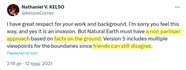

So, no international law, no annexation, no death and seeds of a future war… just “your outlook.”
Now, even taking aside the moral aspect (an old peaceful dispute about some middle ground is not the same as illegal annexation, not recognized by any international law), what is the use case of those so-called “facts on the ground”?
“Crimea is Russia” is a useful “fact” only for russians. For most of the other contexts, there is a huge BUT. It is illegal internationally to enter Crimea through Russia to travel; to have business with it like “just a region.”
For most scientific purposes (like demographics), it can’t be clearly considered a regular region either. The number of use cases where this “ground truth” is more useful than observing international law is minuscule.
But “Mapping Committee” and Mr. Kelso, like typical Westerners, have decided it is easier to ignore the nature of what’s happening and just make peace with “facts.” It is this approach of “let’s get over it” that to led to the current full-scale war.
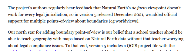
In response to criticisms, version 5 of Natural Earth (Dec 2021, two months before the full-scale invasion) introduced “alternative point of view” datasets (see nauseating “friends can disagree” above).
Since that version, one can download a dataset with Crimea belonging to Ukraine—named, of course, not “internationally recognized borders” but “Ukraine’s point of view.”


The corresponding policy explanation is written with palpable hubris: “Our primary data is correct, but if you muggles are so dumb…”
Obviously, no accidental geo-library user that just wants to experiment with some data will use “alternative datasets” they’ll just go with the default one (moreover, many libraries using Natural Earth data don’t even hint at the options). And that’s why this decision is awful.
For seven years already, people in the world who just do anything with geographical data have been exposed to “Crimea in Russia” as the default. People like university students studying some GeoPandas. Or creators of infotainment maps about the “most popular name by country.”
Those who were students or lazy Internet wanderers in 2017 might have become policymakers, journalists, and advocates. With that subconscious bias of “that’s how things are” and corresponding skewed view on rights and wrongs in this war.
Conveniently, the last Natural Earth data update was in May 2022. A few months before Putin proclaimed that a few “new regions” belong to Russia, too. I thought the developers stopped to reconsider their position in the new light, but…

According to Mr. Kelso’s Twitter, they are working on version 6. For example, improving the road coverage for Russia, because why not?..
Interesting thing to note on these screenshots there are two bold “border lines” on both sides of Crimea:
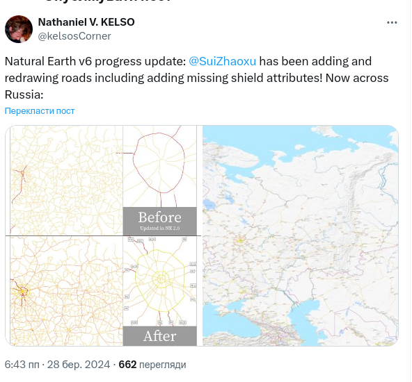

Another interesting thing is that “new Russia regions” seem to not be recognized as “ground truth.” I wonder, what gives?.. Is it not truth enough that Mariupol is “russian” to the same extent as Sevastopol is? Or would we actually see the ground truth™ applied in the the final release of Natural Earth 6? What an interesting challenge for a cartographer it might be, so many changes, so many uncertainties!